This is the third blog post in a series about a three-year project to develop a rapid assessment tool to measure carbon storage in boreal forest wetlands, which involved SRC, the Sustainable Forestry Initiative (SFI), Louisiana-Pacific Canada (LP), Spruce Products Ltd (both SFI Program Participants), Ducks Unlimited Canada (DUC), and Brandon University. The purpose of the project was to better understand carbon storage in wetlands and provide guidance on how to measure it.
- Part 1 - Wetlands and Carbon – Filling the Knowledge Gap
- Part 2 - Why We Need to Learn More About How Wetlands Store Carbon
This is a contributed post written by a former SRC employee, Mark Johnston.
Looking back over the three-year life of this project, it’s impressive to see how much was accomplished. We did intensive planning the first year, including both detailed mapping and field testing of the protocol. This enabled the field crews to be very productive from the start, sampling approximately 960 sites across 60 wetlands in two field seasons. The project is a good example of collaboration among conservation organizations to support solutions to global climate challenges.
A strong partnership was also important to the success of this project, with each member of the team providing complimentary expertise:
- Ducks Unlimited Canada (DUC) provided geographic information system (GIS) and other mapping support and expertise with previous field sampling
- Louisiana-Pacific and Spruce Products provided project coordination and field crews, logistical support and forest inventory data
- Brandon University did all of the lab analyses
- SRC used the peat and vegetation data to generate estimates of carbon storage for each wetland
- The SFI Forest Management Standard protects riparian areas like swamps, fens and bogs, protecting both the water quality and quantity and the carbon stored in these environments.
Now that the work has concluded, it’s time to review the project findings; the results of which will help forest managers estimate carbon storage in wetlands as part of their land management activities.
The Field Work
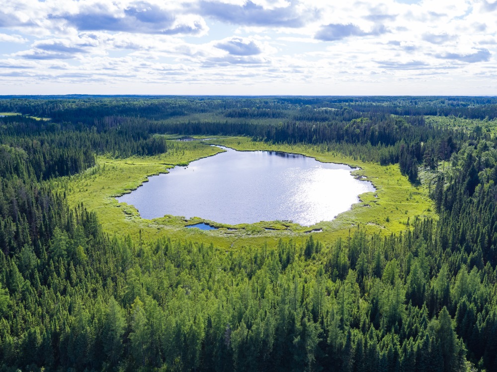
Our sample design included all wetland types identified in DUC’s Wetland Classification: bogs, fens, marshes and swamps.
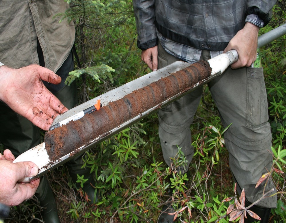
Samples of peat and measurements of the vegetation were done in 2016 and 2017. Peat was sampled using a manual corer that cuts out a half-cylinder of peat 50 cm long. Previous work in boreal peatlands has shown that a single core taken from the 50-100 cm depth provides a good representation of peat characteristics.
Tree and shrub measurements were taken so that the carbon in peat and vegetation could be combined into a landscape-level estimate of carbon in the wetlands. Trees were measured for stem diameter at breast height, a standard measurement in forest inventory. Tall shrubs were measured for stem diameter at 15 cm above the ground surface, and small shrubs were measured for percent cover, which is the amount of ground surface covered by the plant’s foliage.
Carbon in trees was estimated by using allometric equations – these are equations based on a relationship between an easily measured characteristic like stem diameter and the tree’s total biomass. These equations are available for every tree species in North America and have been used for many years.
Similarly, tall shrub biomass is estimated from stem diameter, and low shrub biomass from percent canopy cover. Normally biomass is assumed to be 50 per cent carbon.
Peat deposits are three-dimensional, so depth is a critical aspect of determining peat carbon mass. We laid transects across the wetlands and sampled peat, vegetation and peat depth along these lines. The peat samples were then sent to the lab at Brandon University where peat bulk density and carbon content were measured.
We then combined the peat measurements with depth and wetland area to estimate the total carbon mass in peat and combined that with estimates of carbon mass in the vegetation, for a total estimate of carbon in each boreal wetland (e.g., bog, swamp).
The Results
We found that the depth of peat varied from about 1 meter to a maximum of 6 meters, and that wetland area ranged from 3 to 200 hectares, with an average area of 15 hectares.
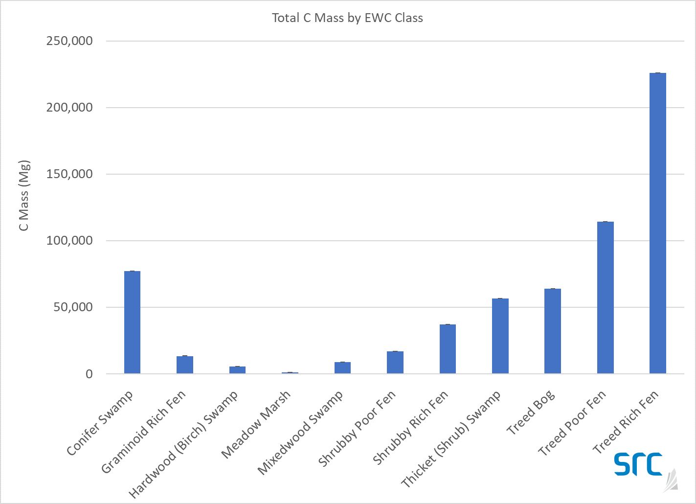
As you can see in the chart below, average wetland carbon mass varied from a low of about 1,000 tonnes in marshes to a maximum of over 200,000 tonnes in treed fens. Wetlands with tree cover tended to have more peat than those with just shrubs or aquatic vegetation, and therefore had more carbon stored in the peat and the vegetation.
This helps forest managers understand which wetlands have the most carbon and why conservation is important.
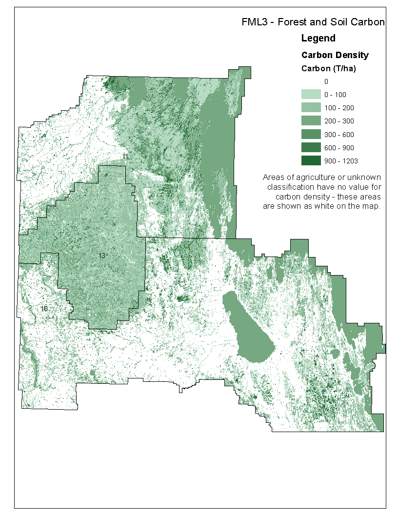
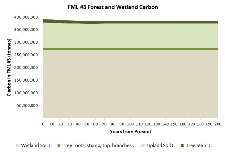
Results Across the Landscape over Time
For the first time in Western Canada, estimates of carbon for both the uplands and wetlands are included together (see graph below). LP recently completed a Forest Management Plan for the Duck Mountain area that utilized these carbon storage estimates.
This holistic view of the ecosystems with carbon show us some very interesting results:
- Across the Duck Mountain and surrounding area, wetlands contain significantly more carbon (70%) than uplands (30%). This result is not intuitive, since wetlands are only a quarter of the area’s land base.
- Upland soils contain the second largest pool of carbon.
- Carbon stocks are estimated to be stable and sustainable over the next 200 years, even with annual tree harvesting and removal of tree stems. Note that the tree roots, stump, top and branches are left on site.
The Guidebook
An important goal of the project was to provide guidance to forest managers on how to sample carbon in wetlands, in both peat and in vegetation. Carbon storage in upland forests is pretty well understood, whereas carbon in wetlands is less clear. This is because upland forests are often under management while wetlands are generally not. The work we’ve done now gives forest managers the method and tool they need to do this, as well as provides crucial data about carbon stored in wetlands.
We have produced a guidebook for the Sustainable Forestry Initiative (which continues to invest in methods to better quantify the carbon stored and sequestered annually in managed forests), as well as a technical document, that explains more of the science behind the protocol.
The guidebook walks forestry practitioners through a step-by-step procedure for how to design a sampling regime and apply it in the field, and how to collect the information required. It’s general enough that it should apply, perhaps with some modification, to most forested wetlands in northern North America.
