This is a contributed blog post written by former SRC employee Patty Ogilvie-Evans.
SRC is remediating 35 abandoned uranium mine and exploration sites located near Uranium City in northern Saskatchewan, as part of Project CLEANS (Cleanup of Abandoned Northern Sites).
Ore was not processed at these mines, but was shipped to the uranium mills at the Lorado Mill Site and the Eldorado Mine. Because there are no tailings present, these sites are called satellite mine sites and they pose public safety hazards and in some cases, have potential environmental impacts.
The Challenges of Remediating Satellite Sites
What you can see on the surface of the satellite uranium mine sites doesn’t always tell the full story of the mining activities that took place. In fact, the surface is a very small part of the whole remediation process.
As a geoscientist working on the Project CLEANS team, I help recreate what happened at these old uranium sites, going through archived files and all the underground plans.
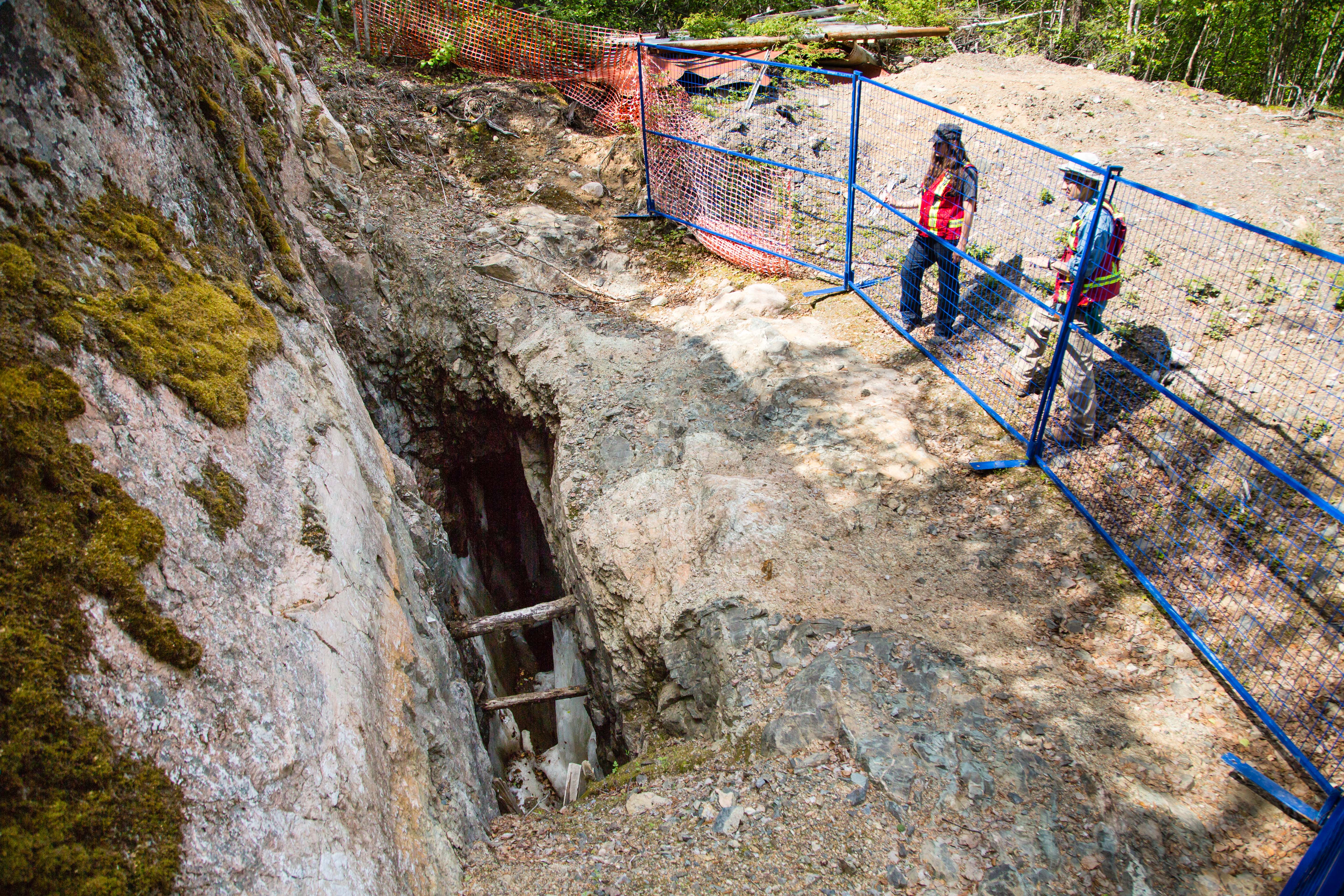
It’s important to understand what happened underground, so we can get a better idea of any risks on the surface. Underground mine workings can reach the surface by way of an open mine shaft, ventilation raises from underground or thin areas between the underground workings and the ground at surface. Once we have a good understanding of any hazards associated with the underground mine workings, we then approach surface remediation and develop a site remediation plan. As part of our overall plan, we work with consultants to conduct critical risk and hazard assessments for underground workings.
We want to make sure the work we’ve done creates a safe environment and reduces risks to the public and wildlife – that’s a key part of our remediation. Our intent is that eventually the land can be used again for hunting and fishing, but in some cases, we’re just cleaning it up so that no further damage is done to the environment and people. We’re thinking long term, it’s not just dealing with the risks we see today.
When you’re working with 35 sites, you come to see that each one has its own story. It’s interesting trying to figure out the intricacies of each site, which vary greatly.
Investigating Historical Documents
To find all the potential hazards, we spend a lot of time going through old reports and newspaper clippings - anything from that time - to build a backdrop of what happened at the mine.
For instance, we may find out they sunk a shaft, and then we need to determine where to look for it. Sometimes it’s pieced together from different knowledge areas, such as newspaper clippings and mine plans. It is important to remember that these are records from the 1950s and 60s, so there’s a lot of detective work in trying to piece together what may have happened. The archival reports also show historically where site infrastructure (e.g., buildings, oil or gas tanks) were sitting.
While we do have access to some information about these sites, I was surprised at just how much was missing – a sign of the times and lack of regulatory requirements during that period. The absence of key information has made it more challenging, although not impossible, to figure out the history of these sites. It’s a matter of examining all the resources available to come up with the story, like scanning documents, reading reports and even using software to recreate the site histories.
In the Field: Georeferencing
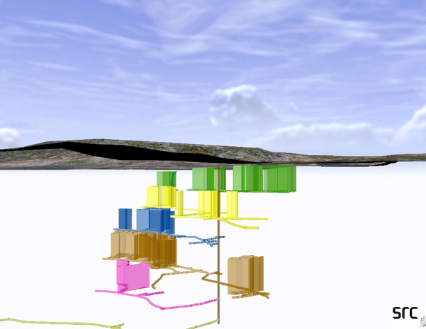
Using the collected data and software, we’ve created three-dimensional models for a few of the sites to help us locate the mine opening hazards, mine shafts, areas of unstable ground and areas where the underground has opened to the surface. This enables us to see a three-dimensional view of what the mine looked like underground. Instead of blindly walking around the surface, without having any idea of what’s underground, we physically can see what is below our feet.
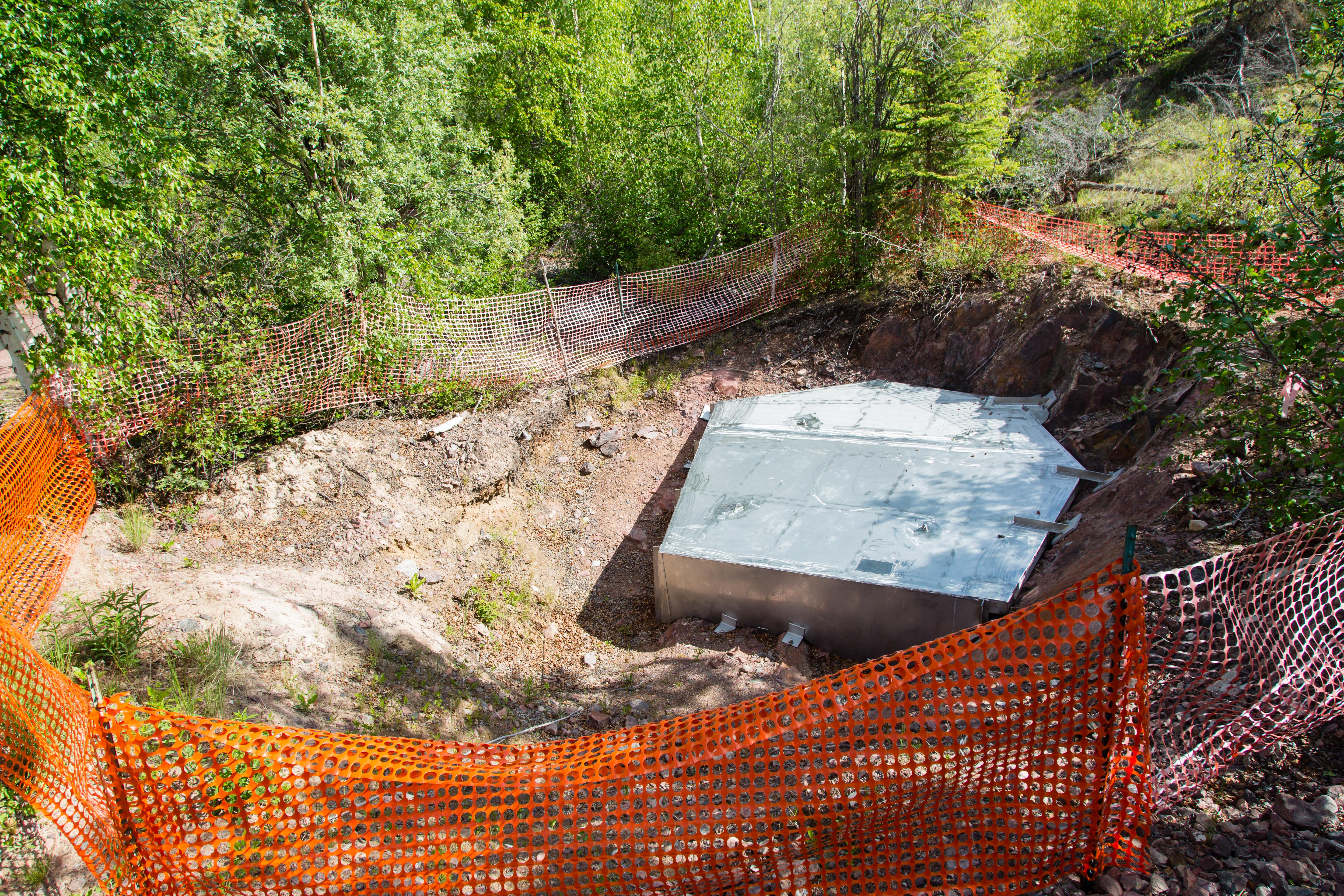
Once we have a fair amount of information about the underground layout of a mine, we georeference some of the points on the surface directly above. Georeferencing is the process of associating a scanned map (for example) with geographical data and real-world coordinates. We generally create the maps in the office using software and combine them with the underground overlays onto a new map that we take with us to the sites. Frequently, we even use a mobile app that enables us to import the digital maps and use them like a GPS map while on site (similar to using Google Maps in a city!). If we see from our underground model where a mine opening potentially is, georeferenced to a point, then we send our field staff out there to find it on the surface and determine remediation options, such as installing a stainless-steel cap.
For example, we’ve been to a site where there were a few spots that concerned us about what was beneath the ground surface. Once we looked at the underground workings and projected in three-dimension where the mining actually took place, we discovered there was a big cavern (i.e., mining stope) below our feet. This assessment method allows the underground to become less of a mystery.
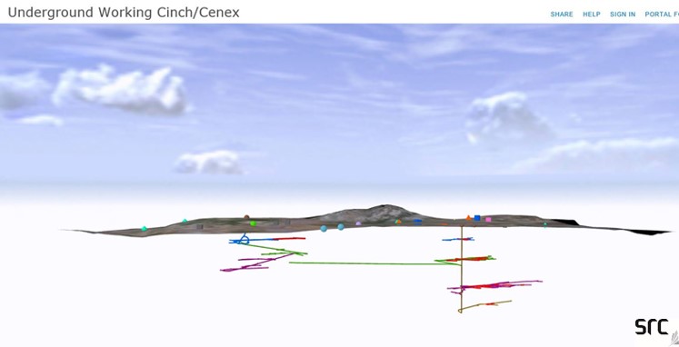
Uncovering Cinch Cenex
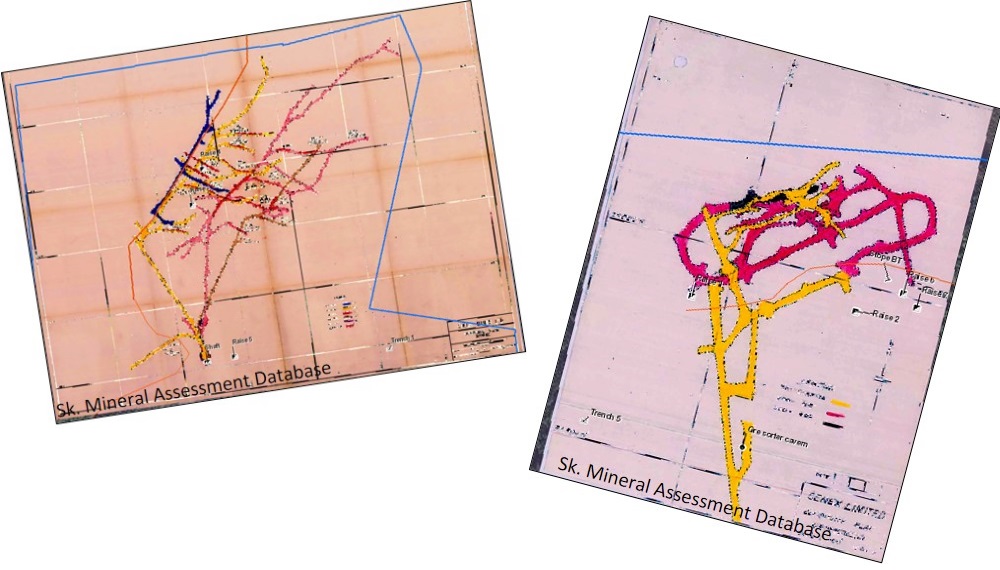
One of my favourite satellite sites is called the Cinch/Cenex mine site, which operated from 1955-1960. About 200,000 tonnes of uranium ore was mined at the site. It has two names because there were two mines that operated on that site location, both at different times.
To get a better understanding of the underground workings, we used historical drawings and overlapped them onto surface maps. Using software, we took the two-dimensional overlay and put it into three dimension because the mine layout was so complex. This enabled our team to view the underground workings from different angles, such as a view from the side or the surface.
We learned there was a lot of surface drilling on the site, but they also sunk a shaft in the mine and had four levels of underground workings. Additionally, the mine operated a water treatment plant and a settling pond.
Lasting Impressions: Community Engagement
I like the challenge of finding out the history of a mine site, and piecing it together using every bit of knowledge available – not only geological, but from other sources too. It’s rewarding knowing we can potentially fix these risks and hazards at the abandoned mine sites so it’s safer for the environment, wildlife and people. From what we have learned talking to the surrounding communities, they’re happy we’re cleaning things up and that we’ve involved them in planning remediation options.
Our underground models and overlays have helped us show the communities, regulators and stakeholders what’s beneath the mine sites’ surface. It helps people see the reason why we propose certain remediation solutions and why certain options won’t work. It also helps keep our field crews safe, when they aren’t able to see what’s beneath their feet. Understanding the underground mine workings is a critical step in the remediation process. The surface level is often just the beginning of a very complicated story.
Interesting in learning more?
You can learn more about the history of the satellite sites and our remediation progress on our website.
